

There it is. At the mine landing at the end of the access road the car is button shifted to ‘P.’
I am about to drive onto the most southern ice road in Canada.
It was one of those grey days when the winter light is so flat, but the northern, expansive horizon, island-studded, with the white and green of Temeeaygaming - Lake Temagami becomes an inviting contrast.
That idle is 18 km west off of Highway 11 North, just south of Temagami via the - Lake Temagami Access Road.
Temagami First Nation winter ice road
To my right is the sign: ‘Temagami First Nation,’ with snowflake icons bracketing ‘ICE ROAD’ in caps. The school bus type of yellow sign has additional safety and driving icons.
The seat belt is unbuckled, and then I power down two windows.
Bundling up in the -20C temperatures was not an immediate concern. I was thinking more about the unwritten colloquialism – often offered - of safety first – when you’re driving a heavy vehicle across an ice road, be prepared. (I did not wear a PFD, it was suggested prior to the visit by someone who is really anxious about the concept of driving an ice road.)
On the Temagami First Nation website it says “Friendly reminder when entering and exiting the road reduce speed to 20 kph and while on the road 40 kph is the maximum.... and “Be further advised vehicles travelling off the marked ice road do so at their own risk.”
An 82-year-old snowmobiler drowned on Jan. 6 of this year on the lake. The tragedy is a reminder of the vagaries of the changing weather patterns and ice conditions. This year the transition, without access, from open water to freeze up was about six weeks.
On Feb. 1 the ice road limit was posted as nine tonnes (1000 kilograms per metric tonne or about 2200 pounds) my Honda Pilot is approximately two tonnes. (Remember metric measure is easier.)
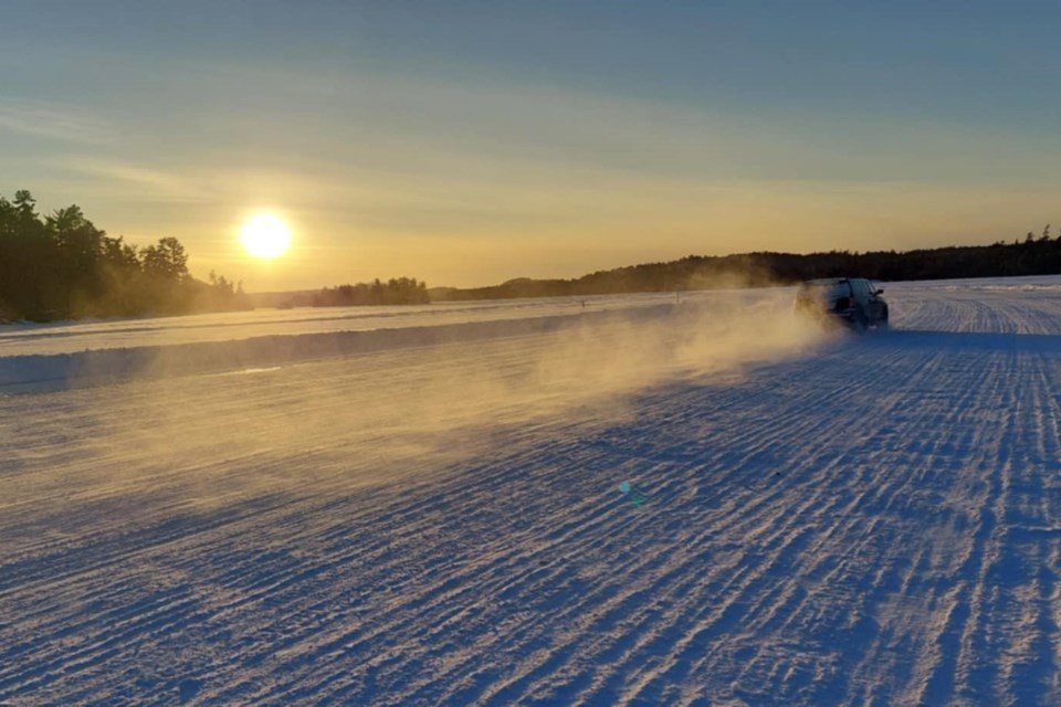
You don’t realize you are driving across a lake, you pass ice huts just off the road and in the near distance all those island camps/cottages the lake is famous for. There are a few heaves and bumps and occasionally you see fissures where the water has made its way to the surface. It is usually on the edges where there is some discoloured slush. It is a smooth ride though.
The road is certainly wide enough consistently what appears to be five to six car lengths across. It looks like a frozen freeway - anywhere else it would be a four-lane highway without a median, but speed is not of the essence here, safety is.
It is a lifeline for the First Nation community not only a way to transport goods and materials to the community but for getting back and forth to the mainland for everything from doctor's appointments to groceries to employment.
Stopping for a quick photo opp a vehicle speeds by,- too fast - you hear the rolling dark rumbling, like thunder, of the underwater wave approach – a little disconcerting. Yikes – quickly back and into the car with the door open.
Onward to Temagami First Nation -– (Makōminising- Bear Island Indian Reserve No. 1 - 1971). Less than 300 people (Teme-Augama Anishnabai) live on the perimeter of the island which has an area of 4.66 km2 (1.80 sq mi). The road opened on Jan. 22 and the limit then was three tons for 'light vehicle traffic.'
(The community itself has a squid-like myriad of narrow roads that climb the undulations of the island’s geography to a hub. There’s one small confectionary store (by the Canoe House and HBC 1843 historic plaque), the very closed St. Ursala’s Catholic Church (the elevated steep front steps provide a sloped toboggan run), Laura McKenzie Learning Centre, (JK-8), the Doreen Potts Health Centre, daycare, the band office, construction accommodation trailers and an array of community service buildings. Find the compelling bronzed statue of a warrior, found in front of the band office, bow and arrow pointing hopefully to the sky. On the tour, the beauty of the lake is always in sight – stunning – a peaceful place to live.
A standard transport truck and trailer can typically carry around 36 metric tonnes (equivalent to 80,000 pounds). Following the reflective markers on the plowed banks it takes seven minutes and forty-four seconds to navigate the 4.96 kilometres (GPS track) from solid land to the next terra firma and that’s abiding by the set speed limits. (“Get over it, the road is very safe.” And I found out that it is.)
Ice master
An enlightening conversation was had with John Charyna, Community Infrastructure Lead for Temagami First Nation. He knows the science of ice making and has been looking after the road and the boat shuttle for about nine years (two different stints).
John confirmed the consistent width of the road is 120 feet or 36.5 m. and the ice thickness, checked on Thursday prior, at 14 inches or 35.5 cm. “It is checked twice a week.” They have an ice chart to match thickness with the allowed tonnage as posted.
With John, it is always safety first. “It is always a little nerve-wracking at the start of the season when we first start checking the ice,” he said. “Our policy says we don’t go out until there are five inches of black ice.” All workers wear floater suits. Snowmobiles are used at the beginning and what starts as a trail is packed and dragged. He said the wind can play havoc with the quality of making ice and often there are open water pockets to scrutinize carefully.
The road is flooded, as needed, by portable pumps to create better ice, three holes are drilled across the road at equal intervals to disperse or spray the water evenly to the edges. The ice beyond the defined banks is thinner.
“Global warming continues to affect the time between winter freeze up and spring break up.” Last year the ice road did not open until February 3 and was only available to the community for ten days. At the time he showed an Elder an ice core with an abundance of air bubbles. The community member, who traditionally checks the ice, said this was rare and was an indication of weaker ice, not what they wanted.
The Copperfields Mine, known as Temagami Mine, operated on nearby Temagami Island from 1955 to 1972. There was a maintained ice road from the mine, via the northeast arm, to the Town of Temagami, then the access road was eventually created to the landing.
History indicates that on occasion trucks have gone through the ice but “Not on my watch,” John said. In 1998 when the sewer and water system was installed on the island there was more than 40” of ice for the larger construction trucks.
John says the speed restrictions are critical to not creating the underwater waves which affect the rigidity or stability of the ice road.
Nazneen Mehdi is a contract nurse who has been working at the Doreen Potts Health Centre on Bear Island for three years. She relies on the winter road and the three-season boat shuttle to get to work. She says the beauty of the land as it moves through the seasons is captivating.
She describes reality, “The boat shuttle to the island carries goods and people several times a day and in the winter, by snowmobile and ice road when the ice has formed. The well-maintained ice road in the deep winter opens possibilities for more independent travel and carrying essential supplies, which is more challenging at other times.
“The sense of strong community and knowledge of traditional ways is central to the success of coordinating daily life. When I am on the island, there is a sense that time has slowed down, and the silence is a relief from an often hectic pace of life."
You can see some historical data of spring break up and freeze-up on the lake.
See the map and road status.
Shortest road
Then there is the shortest ice road in Canada but it is not really a road but a bridge, it is worth the drive to see this scientific marvel.
Making a backyard rink is one thing, constructing an ice bridge suitable for cars and trucks to cross 210 metres (690 feet) of the Abitibi River, with a current, under northern weather conditions, is another skillset worth appreciating.
You can find this ice bridge and three-season ferry crossing 34 km northwest of Cochrane on the 49th parallel, north latitude. Highway 579 was extended north of the Abitibi River in the late 1950s.
The ice bridge and ferry (one of the few cable ferries in northern Ontario) allows the road to continue for approximately five kilometres on the east side of the river, terminating at the Ontario Northland Railway tracks; there are a few full-time residents on the other side of the river.
The ice bridge and ferry are used by snowmobilers, ONR personnel, and logging operators; the vast majority of users cross the river to access hunting and fishing camps and the busiest time is the May long weekend.
How is it built? Through the procurement process, an independent contractor does it. When there are 14 inches of ice (35 cm) fourteen cables (0.5 inches thick), equally spaced, from a spool, are unravelled all the way across the river. Then subsequent flooding quickly makes more ice on top of the suspended cables. It is like putting rebar (short for reinforcing bar) into concrete for additional support.
It then becomes a bridge, developed by watering above the existing ice to create a new, deeper, stronger surface. There are few such natural infrastructures, engineered like this one, in the world; the reinforcing cables suspended within the ice are the difference. The cables are recovered in the spring on the spools.
At 18 inches of ice (45 cm ) light traffic is allowed and the thickness of the ice is posted – signs are up to 100 cm but there is always more ice than that in the middle of winter. Sand is not allowed on the road as it deteriorates the ice; The ice continues to naturally thicken on its own.
Wetum Road
Some may mistakenly say, “It is a whole lot of nothing.” But if flying over the boreal forest and the Hudson Bay lowlands is not an option for you take the longer winter road to Moosonee and then Moose Factory. It is a whole lot of wilderness and a new awakening.
During the coldest months of the year, the communities of James Bay are connected to Ontario’s highway network by the Wetum Road — a frozen road that stretches about 170 kilometres from Otter Rapids on the Abitibi River to Moosonee and across to Moose Factory.
Rick Poulin is the CEO of the Moose Cree Group of Companies. It was founded in the 1980s with the goal of creating long-term economic growth for Moose Cree First Nation on Moose Factory Island. The group of companies is the business arm of the First Nation and as such manages the construction and maintenance of the Wetum Road.
Rick identified the challenges including the flooding of rivers to ensure they are safe and “at mileage 85 which is a huge swamp. Over the years machines have been sunk in that area.”
He said, “The road allows flexibility for folks of the community and those from the south to travel back and forth much faster and with more flexibility. Also provides folks to attend to things like hockey tournaments, and shopping in the south much more freely.”
The beauty of Wetum Road. is that you start within the boreal forest and transition to the Hudson Bay lowlands. From Smooth Rock Falls on Highway 11 you travel north through mixed-wood forests of jack pine, balsam fir, tamarack and eastern white cedar, along with intermittent deciduous species of poplar and white birch. North of Abitibi Canyon to Otter Rapids you transition to black and white spruce.
Then about 100 km along the Wetum Rd., there are large expanses of bonsai like tamarack and dwarf black spruce with open expanses of muskeg that are dotted with small lakes and ponds.
So what does Wetum mean? It is a combination of the two names of First Nation councillors (Robert Echum and Peter Wesley) who initiated the road-building project.
You have come a long way on the winter road so you visit both communities.
From the end of the terra firma, you cross the Moose River and quickly come to another checkpoint at Moose Factory Island about 16 kilometres (10 mi) from its mouth at James Bay. It is adjacent to the community of Moosonee across the Moose River, from which it is accessible by water taxi in the other three seasons-plus. You climb the river bank the first thing you see is the banked snow for insulation purposes on all the small houses. It is the oldest English-speaking settlement in Ontario, built in 1672. There are a number of original HBC buildings, including two historic plaques located at the Staff House.
Along with the historic cemetery Moosonee is considered to be Gateway to the Arctic and has Ontario’s only saltwater port. The community was the site of a fur trading post set up in 1903 by Révillon Frères, competitors to the Hudson Bay Company which later bought out Révillon. Moosonee is the railhead of the Ontario Northland Railway where goods are transferred to barges and aircraft for transport to more northerly
How to get there. Your journey starts at Smooth Rock Falls between Cochrane and Kapuskasing and north of Timmins. It is 73 km to Fraserdale and you turn right or NE towards Abitibi Canyon another 3.5 km. You cross over the Ontario Power Generation dam and it is another 45 km to Otter Rapids (Otter Rapids Generating Station) and the start of the Wetum Rd.
Here you check in at the gate; name, licence number and purpose of the trip; there are no fees. You are on the east side of the Abitibi River and you start to veer NNE. There are no ice road truckers as this road is for local traffic only and there are no snowmobiles allowed. Depending on the road and corresponding weather conditions you can make good time. But the road can be closed due to intermittent weather and snow-clearing operations; check here for road status.
More on ice roads
The winter roads network provides seasonal connections to the provincial highway network for remote and Far North communities.
The Ontario and Federal governments provide financial assistance to 32 First Nation communities to build and maintain more than 3,200 kilometres of winter roads.
So there you have it a short list of doable ice roads for a winter trek. Be a tourist, take the opportunity to do the double crossing of the Abitibi River, via the ice bridge or the cable ferry (free) when spring arrives.
With Brian Emblin of Timmins we are wondering if we can conquer the Wapusk Trail the longest winter road in the world - 752 kilometres (467 miles) according to the Guiness Book of Records. That would get us again close to the furthest point in Ontario where it meets the border of Manitoba and Nunavit. These were two past Village Media adventure-polar bear/geography stories.
It starts in Gillam, Manitoba, then northeast to Fort Severn, Ontario, then curves slightly south, but still east, through Polar Bear Provincial Park, along Hudson Bay, to Peawanuck, about 30 kilometres inland.
There can be a great deal of thoughtful winter words “biboon ikidowinan” (bih-boon ih-kid-doe win-nuni) on the back roads. Think about going for a drive.


